A Trek in the Himalayas of India - August 2012
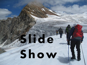
Click here or on image to see the slide show of our trek. Opens in a new window |
 |
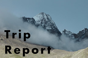
Click here or on image to right to open a PDF of the Trip Report, or you can view the report below. |
 |
For a different perspective on this trek, check out this blog.
| Six minute video - a simple summary of our Trek in the Indian Himalayas | ||
Click on YouTube for a High Definition version of this video (Opens in a seperate window) |
Trekking in the Indian Himalayas
A Trip Report by David Socky
Introduction
My dream of hiking among the 'big ones' in the Himalayas of India was coming true. I was working with Archit Rakheja of Geck & Co, a trekking company out of Delhi, India, on an exploratory hike in the north-west corner of Jammu and Kashmir. But when I told my wife, Mary Sue, that the trek required special permission because it was only miles from the disputed Pakistan/Indian border with Kashmir, this particular hike was nixed. After poring over Google Earth maps, Archit and I came up with another trek - going over the Kalindi Khan's 19,500 foot pass, which was just to the west of Nepal. We were all set for this trek when, just 3 weeks before my flight, several 10 year old bodies of foreign hikers were discovered in the area of our planned hike. The Indian government promptly banned foreigners from hiking in that area. Was this adventure of mine jinxed? Not yet. Again, all the participants decided on a trek near Manali that went over two passes – Kang la and Poat la, both over 18,000 feet in elevation. Archit promised that this hike would give me plenty of my required isolation and remoteness, along with plenty of huge jagged mountains. We were on!
Getting there
On Friday, August 17, 2012, I was on a bus out of Delhi, headed for Manali, a tourist town in the state of Himachal Pradesh. Also on the bus was Archit of Geck & Co, and fellow explorers Paresh Gupta from Seattle, Pravin Jadhav from San Juan, and Eddie Kacherikar from India (city of Pune in the state of Maharashtra). However, the bus was at a standstill, stuck in a traffic jam up on the side of mountain on a road which was little more than a washed out jeep trail, in the pouring rain, at 2am in the morning. The road was full of potholes, nearly washed out around every corner, and barely wide enough to fit two lanes of traffic. We were surrounded by thousands of trucks trying to go over the mountain. We were stopped because vehicles couldn't pass one another at a number of narrow spots in the road. After several hours, it finally got straightened out and we were on our way again. I didn't sleep at all.
After sitting on the bus all night for 17 hours, we arrived in the mountain town of Manali around 2pm. We rested up, packed, and were ready to drive to our trail head at 5:30am the next morning. But first, we had to stock up on food at the market. It was like we were in an Indiana Jones movie, loading bags of food and cooking gear on the top of our Range Rover type vehicle in the dark. The market was a maze of small shops and stalls and during the day, it was crowded with locals, bicycles, 3-wheel motorized rickshaws, and vehicles of all types. With all our gear piled on top of the vehicle and covered with a tarp, 8 of us piled into the jeep and headed for Udaipur – a town near our trail head.
|
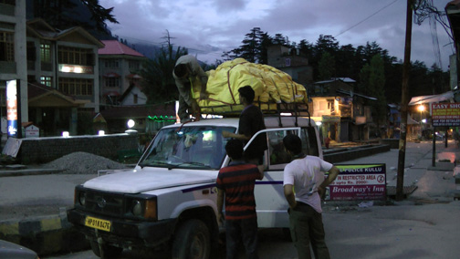 |
The Market in Manali, India |
The trek
Because the trek was planned to be nearly two weeks with extra days built in for bad weather, it was necessary to use porters to help carry all the food and gear. From past experience, Archit organized a full-fledged expedition that consisted of 4 paying customers, Archit from Geck & Co, one local guide, two cooks, and eleven porters. Wow, what a crew – a total of 19 people. With porters being paid to carry gear and food, we were able to travel with 30 to 40 pound packs. If not for the porters, we each would have had to haul 80 to 100 pounds on our backs. Something I don't believe I could have done for 13 days at elevations above 16,000 feet.
|
 |
|
Details of the Trek |
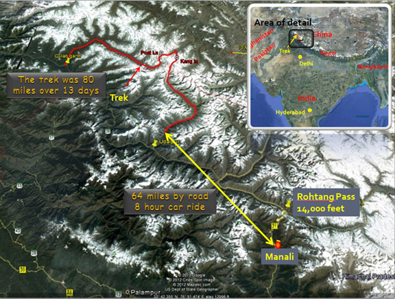
I had mapped our trekking route out on Google Earth and determined it was about 100 miles, which Archit expected to cover in 11 to 12 days of hiking. This was somewhat of an exploratory trip because Archit had never been on this trip before, and our local guide, Prakash, had only done the passes once, on separate trips. So we weren't sure exactly how long the trip would actually be. As it turned out, we were able to drive the first 20 miles from Udaipur to a small village where the road ended, which was our Camp Two.
A few words of caution
We found out the hard way how important it is to be cautious when hiking on loose and unstable rocks. On a day hike above our Camp Two, Eddie got caught on a sliding rock and banged up his knee pretty bad. To make matters worse, his knee had previously been damaged playing soccer. The accident was bad enough that Eddie decided he wouldn't be able to handle the trek, so he ended up taking the bus back to Manali. It was a grim thought about what would have happened if the accident had occurred half way through our trek. No phones, no communications – a rescue would have taken days.
I would also like to take a moment here to stress the need to purify and/or boil your water. I made the mistake of thinking that the clean and pure looking mountain water was ok to drink untreated. Well, it's not. I came down with chills and fever for a night, and then diarrhea, at our second camp. The diarrhea lasted 3 days until Archit's antibiotics finally cured me. It was not pleasant at all. So, always purify your water!
The beginning of the trek
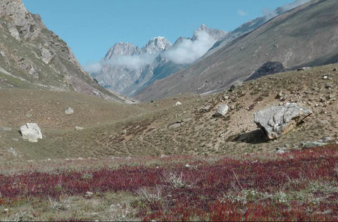
The diarrhea wasn't bad enough for me to bow out of the trek, so we were down by only one person. We started hiking on our second day. The first three days was fairly easy, up a broad valley with many very nice green meadows, which made for great camping. We started at an elevation of 11,400 feet and at Camp Five we were at 13,100 feet, which was the last comfortable camp before climbing up over the passes. These first five days also allowed us to acclimate to the higher altitudes.
 |
This part of the hike involved crossing many side streams coming in from the mountains along our valley. Most had shepherd-built bridges, stepping stones, or were small enough we could cross with ease. On our fourth day, we came upon a large rushing torrent of water which was deep enough that it was necessary to take our boots off and roll up our pants. I had water shoes, but others crossed barefoot in the cold glacial water. The water was so deep and swift, with a bottom of loose rocks, that it was necessary to have help crossing. Trying to cross by oneself, even with a hiking pole, most likely would have resulted in loosing one's balance and being swept downstream. However, everyone made it across without incident. |
An easy start with nice views |
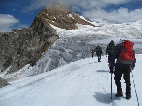
Onto the rocks and ice
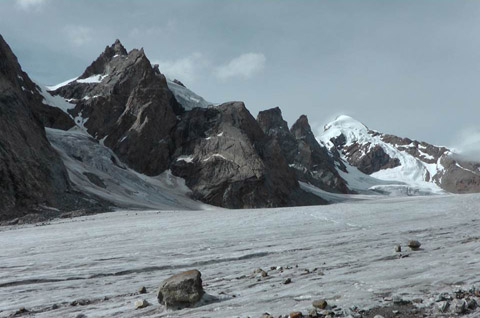
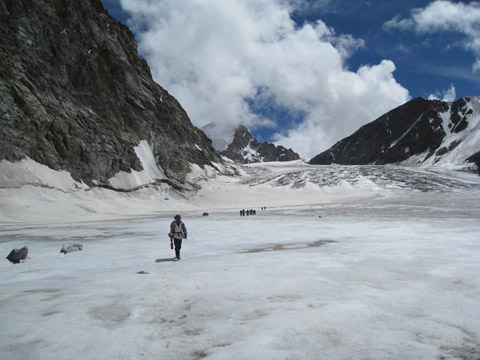
On our fifth day, the easy hiking ended. We were now around 14,000 feet and traveling on glacial moraine and, later in the day, on the glacier itself. The glacier was pretty easy to walk on, but the moraine was more challenging. The moraine was piles and piles of rock of all sizes, with an unpredictable number being loose and unstable. Travel consisted of boulder hopping, scrambling up and down loose scree, and balancing across loose basketball-sized stones. But the scenery and views got better and better the higher we got. Side valleys revealed huge snowy peaks with hanging glaciers flowing toward the main valley.
The weather was varied. We had some days of fog and rain, but more than enough days of sun and blue skies. Luckily, we didn't have any big storms – no torrential downpours or blizzards with high winds. The worst weather we had was fog and drizzle. The stars at night were fantastically bright, with the Milky Way supplying enough light to read by. The early evening moon was even brighter. Our high Glacier Camp, at 16,300 feet, was on a ridge of rock and ice surrounded by flowing glacier. We found several semi flat spots for our tents, where we made a flat floor of rocks over other rocks and ice. Mounds of ice had to be hacked down with an ice axe to make enough room. Believe it or not, it was possible to mold my body around the sharp pointy rocks to get into a semi comfortable position. But I had to sleep in only one position, plus I had to put up with the cold of the ice coming through my thin sleeping pad in a few places. The temperatures were well below freezing, around 25 degrees Fahrenheit. Sleep? Well, I did sleep a little. |
Onto Miyar Glacier |
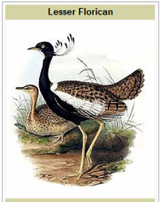 |
The climb up to Kang la Pass started at 4:30am because it was planned to be a long day. We were on glacier almost immediately, which was wall-to-wall ice going up the valley. As the morning clouds and fog broke up, the sun came out and the views just got more and more spectacular. At one point our guide found a large dead bird, of all things, of the side of our route. One of our cooks, Tashi, pulled out a field guide and identified the bird as a "Lesser Florican" (Sypheotides indicus), which is also known as the Likh. It is a large bird in the bustard family. The species is highly endangered and is found mainly in northwestern and central India. |
Crevasses
After climbing a steep rock pile next to a rock buttress and then crossing the front of a steep, creeping ice flow, we gained a wide upper glacier at about 17,600 feet which gave us our first set of crevasses. They weren't big and it was fairly easy to find a narrow spot to step across. We following in each other's footsteps, letting our guide find the safest route. I was sure I stepped in the exact same place as the person in front of me, but maybe I missed by a little, or the snow and ice had loosened up, but all of a sudden both my feet broke through the snow and ice and I fell feet first into a narrow crevasse! Luckily it was narrow because I spread my arms out and stopped my fall with my arms keeping me up. Before I knew it, before I even had a chance to be scared, the hikers in front of me grabbed my arms and hauled me out. Wow, what an adrenaline rush. We stood well back from the crevasse, talking about my experience and watching the porters cross the crevasse. All of a sudden, everyone was running back across the ice field – one of the porters had slipped, dropped his load, and fallen all the way into the crevasse I had just escaped from! The rope came out of a pack, Archit got his rescue hardware out, and a group crowded around the edge of the crevasse. Again, luck was with us and the porter had landed on a narrow ledge about 10 feet down. I didn't know how deep the crevasse really was, but he was successfully pulled out with the rope and only suffered a bleeding hand, cut by the ice as he went in.
Roped up for safety |
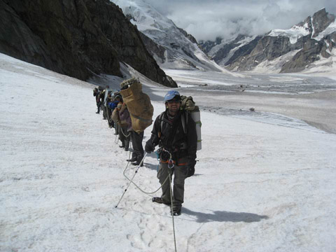
At this point, Archit and Prakash decided we had better rope up since there were plenty more crevasses ahead. There was only one rope, so we had 17 people tied into it, with about 10 to 12 feet separating each person. Our guide, Prakash, was off rope so he could easily find the best route up and over the glacier. Climbing like with this many people on one rope was most interesting – think "slinky"! Needless to say our pace didn't set any speed records.
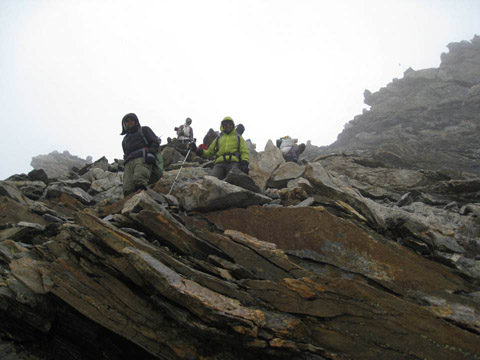
Kang la Pass
The climbing may have been slow, but all of sudden, we were on top of Kang la Pass! I almost missed it, thinking we still had to go up another steep crevasse laden glacier. Handshakes and congratulations made the rounds and many photographs and videos were taken. The mountains, jagged peaks, glaciers, and general scenery from the pass were really spectacular, especially with the blue skies and sunny weather. But we couldn't stay long – it was fairly cold with a brisk wind, plus we had a long way down before we got to our Camp 8.
Kang la Pass - 18,200 feet |
The route down was a lot steeper than the way up, but the upper part was all glaciers, with a huge crevasse field about 1000 feet down. These crevasses were a lot larger and perpendicular to our route down. Because of this, we had to traverse from one side to another looking for a narrow spot where we could jump over the current crevasse. We had to back track uphill a few times because the way down was totally blocked. There was a section where we were on a 10 foot wide track of ice with huge crevasses on either side. Each crevasse was at least 40 feet wide with sharp edges, blue ice, snow bridges and ledges and tons of icicles and ice formations. And you couldn't tell how deep they were, but it was definitely something you didn't want to fall into. It was quit fantastic. |
I was beginning to worry that we would become 'crevasse bound' – finding there was no way down because of blocking crevasses. What would we do? Climb up along the rocks bounding the glacier? Go back the way we had come? I didn't know. But after backtracking one last time, we finally made it through to the end of the crevasse field. We all thanked Prakash for finding a safe route through the maze of crevasses.
| We traversed more ice and snow, and then we were on the rocks and moraine again. We were about half way down at this point. It took forever, but we eventually arrived at Camp 8, a nice spot at the intersection of two glacial valleys. Behind us was the way we had come down, while to the right was down valley which eventually led to civilization, and to the left was up valley, the way to Poat la Pass. We had been at 18,200 feet on Kang la Pass and Camp 8 was at 14,200 feet, and the next day we were to climb to another high camp at 16,800 feet in preparation for going over Poat la Pass, which is 18,500 feet. A little up and down, anyone? |
Coming down from Kang la |
Porter problems
The next day there was a big discussion between the porters, their leader, and Archit. They wanted a rest day, but we couldn't afford the time. Eventually, two porters actually walked out because of the altercation. They went down the valley in the opposite direction of Poat la Pass. It was an all day hike (or more) to a town where they could get a car. According to Archit, it would be a 5+ day drive from there back to Manali. Plus, because they just up and left, they wouldn't get paid, not even for what they had already done. On the face of it, the fiasco was about getting a rest day, but they may have also been worried and/or scared about doing Poat la Pass. Apparently one of the porters had been on a trip when a 'coworker' had died from an accident while going over Poat la. In any case, the load got distributed among the porters who were left and we continued up towards high camp below Poat la.
On to Poat la Pass
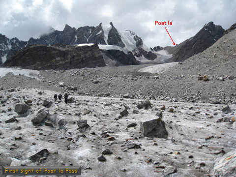
The way up was more glacier and moraine, but mostly moraine. This valley was narrower than the one up to Kang la, with the mountains and peaks higher and sharper. There was more snow along with giant hanging glaciers to our left and wide flowing glaciers to our right. After several hours of hiking, we rounded a bend in the valley which allowed us to see our goal, Poat la Pass. It was a long way away and seemed to require some serious steep climbing and scrambling to get to the top. This was a case where it seemed time was standing still. No matter how long we hiked, we never seemed to get closer to the pass. It seemed a lot longer, but after only five miles, we made it to Camp 9, at 16,700 feet.
Our first view of Poat la |
Camp 9 was a repeat of our glacier camp just before Kang la. It was nothing but rock and ice, with barely enough room to put up the tents. I was so tired, though, that I actually slept quite well that night. We were up early the next day, but we had to wait to see if the weather would clear. It had snowed during the night, and was still snowing when we got up. The wind wasn't too bad, but the clouds looked dark and ominous. However, by 6:30 am the clouds to the east broke up and you could see the brightening sky. That was all we needed to head for the pass. |
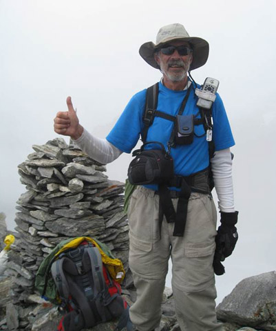
This time I could really feel the thin air, but mostly because the way was a lot steeper. At one spot we had to hack out steps in the ice in order to cross a near 60 degree ice slope. At another spot, as Archit got up from our rest break, he nearly rolled a loose truck-sized rock down on the porters. Luckily it got caught up on a ledge before going over the edge. And then we were at the final climb, a very steep slope of loose rock and scree which almost required rock climbing techniques to get up. This was steep enough and the 18,000 foot air was thin enough that I was forced to do my power step – step 1-2-3-4 step 1-2-3-4 step 1-2-3-4 … I was breathing heavy with my heart pounding when I finally climbed up the last rock and stood on Poat la Pass, at 18,500 feet! The pass was a narrow ridge and was covered with 30 to 40 huge rock cairns that previous hikers had constructed. There was prayer flags strung up between the cairns, which Prakash used to bestow good luck on us with a Hindi chant or prayer. Unfortunately, we were up in the clouds with only 100 feet of visibility, essentially wiping out any views we might have had. We took a few group pictures and then looked at our route down the other side. |
Poat la Pass - 18.500 feet |
Fun coming down from Poat la
Hmmm – even with the clouds and the fog, it was pretty obvious that the other side was a cliff! You couldn't tell how far down it was because of the clouds. But Prakash calmly strode over to one spot and started down, leading the way down a steep, narrow track that wasn't quit straight down. It started to snow. We spread out a little so we wouldn't drop rocks on each other. About 300 feet down, we came to a spot where a 50 degree scree slope had to be cleared of loose rocks and then steps were dug into the rock and dirt so we could cross without sliding down over the cliff right below us. Naresh, one of our cooks, got to the other side of the slope and put his backpack down so he could help with crossing the steep section. As he turned away from his pack, it started to slide down the slope. We yelled a warning and he turned around and jumped to grab his pack, but it slipped out of his fingers and went sliding down were it tumbled end over end with parts and pieces flying off. And then it all went over the cliff and disappeared. Oh shit!
Looking up the cliff to Poat la |
It took us over an hour to get to the bottom of the cliff which turned out to be 1000 feet from the top of Poat la Pass. Naresh hiked back uphill and actually recovered his pack, plus all the pieces that had flown off. He was one lucky dude. I won't say much more about this day except to say that it was a true hike from hell. It snowed, it rained, it was cloudy, and we were on moraine all day long. It was another 2000 feet down to the main glacier where we had a break for about a half hour, but then it was moraine again. We were on moraine for 8 miles, finally getting to Camp 10 at an elevation 14,700 feet. Our camp was an itty bitty little meadow (aka a strip of dirt) set among a bunch of rocks, overlooking massive amounts of moraine. |
The exit
It took us another three days to get back to civilization - the town of Gulab garth. The night before Gulab, we actually slept in a farmer's house in the small village of Dangel. There was homemade beer and liquor, which flowed freely among our expedition members. We had a party in the cook tent where Archit and a porter danced wildly to the drums and the singing of Naresh, our cook. Several villagers, including the town drunk, came by to watch the festivities. It was a really bizarre scene.
Everyone paid for it the next day, though, because the hike from Dangel to Gulab garth was 22 miles. Archit and I didn't get into town until after dark where I immediately downed two 20 ounce bottles of Mountain Dew – boy was that good! And thus, our great trek and adventure in the Himalayas of India ended. As far as I was concerned, it was the trip of a lifetime, one of the greatest adventures I'd ever been on. I'll admit that at times during the hike, I said to myself, "What the hell am I doing here?", "Why am I doing this to myself?", "This really hurts". But in the end, it always comes down to the same sentiment – I would do it all over again, in a heartbeat. I can never get enough of the mountains. |
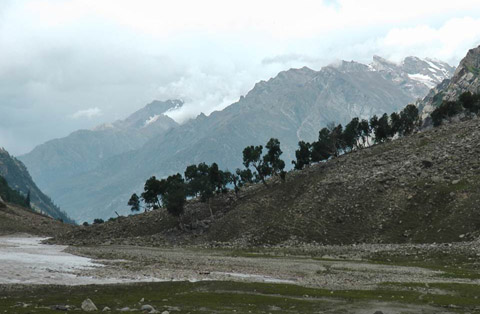
Below the tree line |
The End